![]()
![]()
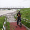
幸手権現堂公園あじさいまつり ![]()
2012/06/17 10:52 - 15:58 / Japan 埼玉県
![]()
| Total distance: | 63.16 | km | Trip time: | 5:05'50 | Average speed: | 20.4 | km/h | |
|---|---|---|---|---|---|---|---|---|
| Ascending altitude: | 96 | m | Descending altitude: | 98 | m | Total calories: | 1054 | kcal |


幸手権現堂公園あじさいまつり
- Japan・埼玉県 2012/06/17 10:52 - 15:58
-
[Trip time] 5:05'50
[Total distance] 63.16km
[Average speed] 20.4km/h [Ascending altitude] 96m [Descending altitude] 98m
[Total calories] 1054kcal
[Tags] Bicycle, Road bike
シンザカヤ
http://bit.ly/KckDia
北の麺房 いちどう
http://r.tabelog.com/saitama/A1104/A110402/11009180/
権現堂公園
http://www.satte-k.com/index.html


-
- ORBEA ONIX 2009
- View other bikes
kata0320
(
Male /
Japan )
0
1

 nagato
GPX export
Are you sure you want to export GPX data for this trip?
![]()
![]()