![]()
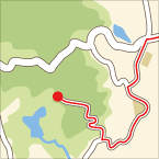
ウスイ谷~弘川への林道 ![]()
2011/04/24 11:48 - 14:42 / Japan 大阪
![]()
| Total distance: | 34.35 | km | Trip time: | 2:54'20 | Average speed: | 13.5 | km/h | |
|---|---|---|---|---|---|---|---|---|
| Ascending altitude: | 761 | m | Descending altitude: | 664 | m | Total calories: | 445 | kcal |
ウスイ谷~弘川への林道
- Japan・大阪 2011/04/24 11:48 - 14:42
-
[Trip time] 2:54'20
[Total distance] 34.35km
[Average speed] 13.5km/h [Ascending altitude] 761m [Descending altitude] 664m
[Total calories] 445kcal
[Tags] MTB, Recreation, Spring
友人と3人でウスイ谷~弘川への林道へ行ってきました。途中登山の御老人集団に遭遇し、「この自転車高いの?」とか「重さどれくらい?」とか「どこまで行くの?」とかの質問攻めに合いました(笑)。僕は用事があったので1周回で帰りましたが友人方はもう一周走ったそうです。+走り終わってから美味しい餃子食べに行ったそうです…羨ましい!!!


-
- TREK MTB 8000
何年も前ですが、これでアメリカの24時間耐久レースとかに参加しました。
View other bikes

OKUDA
(
Male /
Japan )
日本の実業団に登録していますが、練習不足のヘッポコレーサーです。


 sjo
sjo