![]()
![]()
ツール・ド・にし阿波 ![]()
2011/05/15 09:07 - 13:06 / Japan 徳島県三好市池田町
![]()
| Total distance: | 74.11 | km | Trip time: | 3:59'37 | Average speed: | 22 | km/h | |
|---|---|---|---|---|---|---|---|---|
| Ascending altitude: | 1153 | m | Descending altitude: | 1173 | m | Total calories: | 1463 | kcal |


ツール・ド・にし阿波
- Japan・徳島県三好市池田町 2011/05/15 09:07 - 13:06
-
[Trip time] 3:59'37
[Total distance] 74.11km
[Average speed] 22km/h [Ascending altitude] 1153m [Descending altitude] 1173m
[Total calories] 1463kcal
[Tags] Road bike, Hill climb
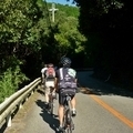
チャレンジコースに行ってみました。
吉野川運度公園から南の山を登る登る。
普段は300mくらいの山しか上がらないのでいや~登る登る。
チャンピオンコースだとさらに倍くらい登るみたいです。
天気も良かったし山が綺麗で気持よかったですね。
ゴール地点のそば米汁もまかったし、
イベントって楽しい。


-
- trek1.2
アルミですが乗りごごちも良いと思います。 ブレーキがちょっと残念な効き具合でしたので、 シマノに換えています。
View other bikes
masa
(
Male /
Japan )
ロードバク初めました。 近所の山に遊びに行ってます。
0
3

 Hinata0731
GPX export
Are you sure you want to export GPX data for this trip?
![]()
![]()