![]()
![]()
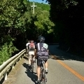
青野ダム ![]()
2013/05/26 10:20 - 14:22 / Japan 兵庫県三田市
![]()
| Total distance: | 66.6 | km | Trip time: | 4:01'05 | Average speed: | 18.7 | km/h | |
|---|---|---|---|---|---|---|---|---|
| Ascending altitude: | 805 | m | Descending altitude: | 821 | m | Total calories: | 1542 | kcal |


青野ダム
- Japan・兵庫県三田市 2013/05/26 10:20 - 14:22
-
[Trip time] 4:01'05
[Total distance] 66.6km
[Average speed] 18.7km/h [Ascending altitude] 805m [Descending altitude] 821m
[Total calories] 1542kcal
[Tags] Road bike, Mountain, Summer
快晴で気持ちのいい日です。
ちょっと暑めで夏が近いかな。
いつも素通りしちゃうんですが、青野ダムによってみました。
地元って言ってた赤ピナレロのお兄さん
前引いてくれてサンキューでした。
また走りましょう


-
- madone5.2
買ってしまいました。
View other bikes
masa
(
Male /
Japan )
ロードバク初めました。 近所の山に遊びに行ってます。
0
1

 Satoru
GPX export
Are you sure you want to export GPX data for this trip?
![]()
![]()