![]()
![]()
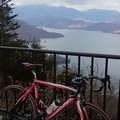
大平山 謙信平 ![]()
2014/08/06 08:12 - 11:36 / Japan 栃木県栃木市
![]()
| Total distance: | 41.67 | km | Trip time: | 3:23'42 | Average speed: | 19.8 | km/h | |
|---|---|---|---|---|---|---|---|---|
| Ascending altitude: | 536 | m | Elapsed time: | 1:59'18 | Total calories: | 829 | kcal |
| Split time | 00:01’08 | |
|---|---|---|
| Lap time | 00:01’08 | |
| Trip lap distance | 10.11 | km |
| Average | Maximum | |||
|---|---|---|---|---|
| Lap speed | 10.3 | km/h | 25 | km/h |
| Lap heart rate | 138.5 | bpm | 163 | bpm |
| Lap cadence | 50.1 | rpm | 87.5 | rpm |
大平山 謙信平
- Japan・栃木県栃木市 2014/08/06 08:12 - 11:36
-
[Trip time] 3:23'42
[Total distance] 41.67km
[Average speed] 19.8km/h [Ascending altitude] 536m [Total calories] 829kcal
[Tags] Road bike


-
- PINARELLO FP1
- View other bikes
0
0

 nippondanji
GPX export
Are you sure you want to export GPX data for this trip?
![]()
![]()