![]()
![]()
赤城からの下り ![]()
2013/06/15 07:06 - 07:37 / Japan 赤城山
![]()
| Total distance: | 16.62 | km | Trip time: | 0:31'37 | Average speed: | 37.3 | km/h | |
|---|---|---|---|---|---|---|---|---|
| Ascending altitude: | 8 | m | Descending altitude: | 1164 | m | Total calories: | 710 | kcal |


赤城からの下り
- Japan・赤城山 2013/06/15 07:06 - 07:37
-
[Trip time] 0:31'37
[Total distance] 16.62km
[Average speed] 37.3km/h [Ascending altitude] 8m [Descending altitude] 1164m
[Total calories] 710kcal
[Tags]


-
- Panasonic 06’ ハリヤ
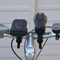
ハリヤの一番古いバージョンに乗っています。もう5年半くらい経ちますが、元気に走っています。タイヤは1.5の細めのタイヤに変えています。坂や発進、向かい風のある所では最強で、ハリヤは、どの自転車に乗るよりも早いです。最近は、ガジェットなどがハンドルを埋め尽くし、だいぶ、ハンドルにコテコテ付いて来てしまいました。バックミラーを最近付けました。調子いいです。通勤に主に使用します。
View other bikes
telltell
(
Male /
Japan )
電動自転車で通勤しています。風が強い時や、坂道、発進時の時はこれがないと走る気がしません。最高スピードは抑えられていますが、重量が多少重くても、サスがついていて多少モタモタしていても、電動アシストの恩恵をフルに受けています。なぜ、みんなが電動アシストを乗らないのか不思議です。 群馬県前橋市に在住しています。高崎市の職場まで自転車で通うことがほとんどです。自転車のハンドルの周りが、メーターやら、カメラやらで、だいぶ狭くなってきました。
0
1

 revdocjim
GPX export
Are you sure you want to export GPX data for this trip?
![]()
![]()