![]()
![]()
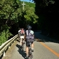
ポンポン山経由で嵐山 その2 ![]()
2014/11/23 09:14 - 15:31 / Japan 京都府嵐山、枚方市
![]()
| Total distance: | 92.34 | km | Trip time: | 6:16'53 | Average speed: | 19.7 | km/h | |
|---|---|---|---|---|---|---|---|---|
| Ascending altitude: | 807 | m | Descending altitude: | 704 | m | Total calories: | 1676 | kcal |


ポンポン山経由で嵐山 その2
- Japan・京都府嵐山、枚方市 2014/11/23 09:14 - 15:31
-
[Trip time] 6:16'53
[Total distance] 92.34km
[Average speed] 19.7km/h [Ascending altitude] 807m [Descending altitude] 704m
[Total calories] 1676kcal
[Tags] Road bike, Riverside, Long touring
やっぱり嵐山はすごい人でした。
あんまり紅葉もしてない感じ。
山の中の方が綺麗でしたね。
帰りは桂川、木津川、淀川のCR
淀川まで出ると、快速でご機嫌。
接続が難しいですね。


-
- madone5.2
買ってしまいました。
View other bikes
masa
(
Male /
Japan )
ロードバク初めました。 近所の山に遊びに行ってます。
0
0

 タケマル
タケマルGPX export
Are you sure you want to export GPX data for this trip?
![]()
![]()