![]()
![]()
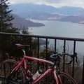
ヤビツ峠 ![]()
2014/12/09 17:45 - 2014/12/28 14:50 / Japan 神奈川県秦野市
![]()
| Total distance: | 42.74 | km | Trip time: | 2:43'05 | Average speed: | 16.7 | km/h | |
|---|---|---|---|---|---|---|---|---|
| Ascending altitude: | 1363 | m | Elapsed time: | 2:27'02 | Total calories: | 1163 | kcal |
| Split time | 00:01’08 | |
|---|---|---|
| Lap time | 00:01’08 | |
| Trip lap distance | 10.11 | km |
| Average | Maximum | |||
|---|---|---|---|---|
| Lap speed | 10.3 | km/h | 25 | km/h |
| Lap heart rate | 138.5 | bpm | 163 | bpm |
| Lap cadence | 50.1 | rpm | 87.5 | rpm |
ヤビツ峠
- Japan・神奈川県秦野市 2014/12/09 17:45 - 2014/12/28 14:50
-
[Trip time] 2:43'05
[Total distance] 42.74km
[Average speed] 16.7km/h [Ascending altitude] 1363m [Total calories] 1163kcal
[Tags] Road bike
小山へUターン途中ちょっと寄り道!
絶好のサイクリング日和でした。


-
- PINARELLO FP1
- View other bikes
0
0

 とっちゃん
とっちゃん
GPX export
Are you sure you want to export GPX data for this trip?
![]()
![]()