![]()
![]()
権現山 ![]()
2015/12/06 09:10 - 13:41 / Japan 権現山
![]()
| Total distance: | 18.81 | km | Trip time: | 4:32'00 | Average speed: | 6.1 | km/h | |
|---|---|---|---|---|---|---|---|---|
| Ascending altitude: | 1158 | m | Elapsed time: | 1:52'04 | Total calories: | 136 | kcal |
| Split time | 00:01’08 | |
|---|---|---|
| Lap time | 00:01’08 | |
| Trip lap distance | 10.11 | km |
| Average | Maximum | |||
|---|---|---|---|---|
| Lap speed | 10.3 | km/h | 25 | km/h |
| Lap heart rate | 138.5 | bpm | 163 | bpm |
| Lap cadence | 50.1 | rpm | 87.5 | rpm |
権現山
- Japan・権現山 2015/12/06 09:10 - 13:41
-
[Trip time] 4:32'00
[Total distance] 18.81km
[Average speed] 6.1km/h [Ascending altitude] 1158m [Total calories] 136kcal
[Tags] Bicycle, Hiking, MTB
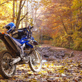
MTB忘年会2015-2
いくら不遇な山と言われた権現山でもハイカーは必ずいるので、出くわしたら下車+挨拶励行は必須で。また意識的なリアロックターンも路面が掘れて溝になってしまうので基本山サイでは禁止ですよ。
Randy
(
Male /
Japan )
http://www.a3jettaglx.com/index.html
0
0

 YASU
YASUGPX export
Are you sure you want to export GPX data for this trip?
![]()
![]()