![]()
![]()
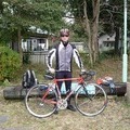
息子とサイクリング ![]()
2012/03/15 10:29 - 14:42 / Japan 東大阪~太子町
![]()
| Total distance: | 46.57 | km | Trip time: | 4:12'32 | Average speed: | 16.8 | km/h | |
|---|---|---|---|---|---|---|---|---|
| Ascending altitude: | 472 | m | Descending altitude: | 437 | m | Total calories: | 615 | kcal |


息子とサイクリング
- Japan・東大阪~太子町 2012/03/15 10:29 - 14:42
-
[Trip time] 4:12'32
[Total distance] 46.57km
[Average speed] 16.8km/h [Ascending altitude] 472m [Descending altitude] 437m
[Total calories] 615kcal
[Tags] Road bike
生駒山西麓から南河内サイクルライン、竹之内街道を経て、道の駅・近つ飛鳥の里太子へ。


-
- basso viper
ロードバイク(basso viper) クロスバイク(ゲイリーフィッシャー) フォールディングバイク(panasonic)
View other bikes
カツヨシ
(
Male /
Japan )
仲間とサイクリングやポタリングを楽しんでいます。 これから仲間を増やし、近畿のみならず、日本全国を走ってみたいです。
0
4

 uesan
uesanGPX export
Are you sure you want to export GPX data for this trip?
![]()
![]()