![]()
![]()
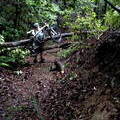
Yamanobenomichi Path. ![]()
2012/05/21 10:01 - 16:00 / Japan Tenri City. Nara Prefecture.
![]()
| Total distance: | 18.75 | km | Trip time: | 5:58'28 | Average speed: | 3.7 | km/h | |
|---|---|---|---|---|---|---|---|---|
| Ascending altitude: | 634 | m | Descending altitude: | 579 | m | Total calories: | 120 | kcal |


Yamanobenomichi Path.
- Japan・Tenri City. Nara Prefecture. 2012/05/21 10:01 - 16:00
-
[Trip time] 5:58'28
[Total distance] 18.75km
[Average speed] 3.7km/h [Ascending altitude] 634m [Descending altitude] 579m
[Total calories] 120kcal
[Tags] Walking, Long touring, Spring
The Yamanobenomichi Path is very famous and popular. Because I ran-out of space on my memory card,I wasn't able to record the entire trip.


-
- Trek 6000
My "baby", the Trek 6000, is a great bike with front-fork suspension, front & rear fluid disc brakes, 29-gears plus all the bells-and-whistles.
View other bikes
theoutdoorholic
(
Male /
Japan )
Hi, my name is Ross-Barry and I am an outdoorholic. For the past 25-to-30 years I have come to appreciate and respect what we have here, on this piece-of-rock we call Planet Earth.
0
0
![]()
![]()
![]()
-
 Afternoon Ride
 keynes
Not set・
2016/12/16
-
 Bush-Bashing in the Soraku ...
theoutdoorholic
Japan・Soraku District. Kansai Redion.
2013/07/25
-
Morning Ride
なっくん
Not set・
2017/06/09
-
Afternoon Ride
なっくん
Japan・寝屋川市
2017/08/19
-
 Shijonawate to Hoshida.
theoutdoorholic
Japan・Shijonawate City, Osaka Prefecture.
2015/05/02


![]()
GPX export
Are you sure you want to export GPX data for this trip?
![]()
![]()