![]()
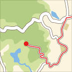
伊吹山 ![]()
2011/05/15 11:34 - 13:50 / Japan 岐阜県 滋賀県
![]()
| Total distance: | 4.51 | km | Trip time: | 2:16'32 | Average speed: | 3.2 | km/h | |
|---|---|---|---|---|---|---|---|---|
| Ascending altitude: | 0 | m | Descending altitude: | 0 | m | Total calories: | 72488 | kcal |
伊吹山
- Japan・岐阜県 滋賀県 2011/05/15 11:34 - 13:50
-
[Trip time] 2:16'32
[Total distance] 4.51km
[Average speed] 3.2km/h [Ascending altitude] 0m [Descending altitude] 0m
[Total calories] 72488kcal
[Tags] Hiking
新幹線で東京方面に行く時、米原を過ぎて関ヶ原のあたりまでくると左手にボテッとした台形の山が見えます。 伊吹山(1.377m)です。 日本100名山のひとつで、冬には真っ白な姿を見ることができます。 今日の伊吹は天気:快晴で琵琶湖の一部や竹生島がよく見えましたが、御嶽や乗鞍は、春かすみか黄砂の影響か、見えませんでした。

きたろう
(
Male /
Japan )


 A.S
A.S

