![]()
![]()
大正池 ![]()
2016/02/28 10:57 - 15:48 / Japan 大正池
![]()
| Total distance: | 80.05 | km | Trip time: | 4:50'58 | Average speed: | 23.2 | km/h | |
|---|---|---|---|---|---|---|---|---|
| Ascending altitude: | 1355 | m | Elapsed time: | 3:28'22 | Total calories: | 1356 | kcal |
大正池
- Japan・大正池 2016/02/28 10:57 - 15:48
-
[Trip time] 4:50'58
[Total distance] 80.05km
[Average speed] 23.2km/h [Ascending altitude] 1355m [Total calories] 1356kcal
[Tags]


-
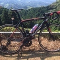
- Wilier GTR
- View other bikes
てっぺい
(
Male /
Japan )
坂、坂、坂が好き。 メタル、ハードコア、パンク、ビール、TATTOO、坂が好きだー。 よろしくです。」
0
0

 kego
kegoGPX export
Are you sure you want to export GPX data for this trip?
![]()
![]()