![]()
![]()
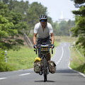
敦賀市ーマイアミ浜キャンプ場 ![]()
2016/05/04 06:23 - 13:45 / Japan 福井県・滋賀県
![]()
| Total distance: | 86.61 | km | Trip time: | 7:22'17 | Average speed: | 16 | km/h | |
|---|---|---|---|---|---|---|---|---|
| Ascending altitude: | 1145 | m | Elapsed time: | 5:46'10 | Total calories: | 892 | kcal |
敦賀市ーマイアミ浜キャンプ場
- Japan・福井県・滋賀県 2016/05/04 06:23 - 13:45
-
[Trip time] 7:22'17
[Total distance] 86.61km
[Average speed] 16km/h [Ascending altitude] 1145m [Total calories] 892kcal
[Tags] Touring bike, Long touring


-
- パナモリランドナー
PanasonicのFSS5で組んだツーリング用バイク
View other bikes
ちゃりだー
(
Male /
Japan )
キャンプツーリング専門
0
0

 マーノリ
マーノリGPX export
Are you sure you want to export GPX data for this trip?
![]()
![]()