![]()
![]()
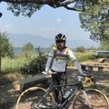
野田、垣生周回。散策 ![]()
2014/01/23 09:49 - 12:22 / Japan 野田、垣生
![]()
| Total distance: | 46.65 | km | Trip time: | 2:32'58 | Average speed: | 21 | km/h | |
|---|---|---|---|---|---|---|---|---|
| Ascending altitude: | 498 | m | Descending altitude: | 492 | m | Total calories: | 886 | kcal |


野田、垣生周回。散策
- Japan・野田、垣生 2014/01/23 09:49 - 12:22
-
[Trip time] 2:32'58
[Total distance] 46.65km
[Average speed] 21km/h [Ascending altitude] 498m [Descending altitude] 492m
[Total calories] 886kcal
[Tags] Road bike, Recreation


-
- リドレー ダモクレス isp
- View other bikes
mnmk7747
(
Male /
Japan )
0
2

 しょうじ
しょうじ
GPX export
Are you sure you want to export GPX data for this trip?
![]()
![]()