![]()
![]()
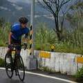
Morning Ride ![]()
2016/09/16 07:10 - 08:52 / Taiwan 風櫃嘴→基隆河→士林
![]()
| Total distance: | 31.07 | km | Trip time: | 1:42'01 | Average speed: | 27 | km/h | |
|---|---|---|---|---|---|---|---|---|
| Ascending altitude: | 318 | m | Elapsed time: | 1:12'08 | Total calories: | 673 | kcal |
Morning Ride
- Taiwan・風櫃嘴→基隆河→士林 2016/09/16 07:10 - 08:52
-
[Trip time] 1:42'01
[Total distance] 31.07km
[Average speed] 27km/h [Ascending altitude] 318m [Total calories] 673kcal
[Tags]
Takamitsu Yoshida
(
Male /
Japan )
0
0

 Takamitsu Yoshida
GPX export
Are you sure you want to export GPX data for this trip?
![]()
![]()