![]()
![]()
ツールドしらかわ ![]()
2016/10/02 08:19 - 13:27 / Japan 福島県白河市
![]()
| Total distance: | 94.45 | km | Trip time: | 5:08'40 | Average speed: | 25.3 | km/h | |
|---|---|---|---|---|---|---|---|---|
| Ascending altitude: | 2108 | m | Elapsed time: | 3:56'28 | Total calories: | 1924 | kcal |
ツールドしらかわ
- Japan・福島県白河市 2016/10/02 08:19 - 13:27
-
[Trip time] 5:08'40
[Total distance] 94.45km
[Average speed] 25.3km/h [Ascending altitude] 2108m [Total calories] 1924kcal
[Tags]
スタートから第一エイドまでエラーのため未計測です。走行距離は約111キロになります。


-
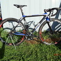
- GIOS GRESS2015
GIOS GRESS2015モデルに乗っています。 コンポは、アルテグラDi2で快適です。 ホイールはFFWD F4RFCCです。
View other bikes
GIOS216
(
Male /
Japan )
自分で組み上げたGIOS GRESS2015に乗っています。 日常は渡良瀬遊水地、太平山、関宿城周辺を走っています。 また、イベント・レースなども参加しています。
0
0

 garcia
GPX export
Are you sure you want to export GPX data for this trip?
![]()
![]()