![]()
![]()
青葉の森 ![]()
2016/12/30 17:48 - 2016/12/31 18:40 / Japan 千葉市
![]()
| Total distance: | 14.52 | km | Trip time: | 24:51'43 | Average speed: | 15.7 | km/h | |
|---|---|---|---|---|---|---|---|---|
| Ascending altitude: | 235 | m | Elapsed time: | 0:50'55 | Total calories: | 177 | kcal |
| Split time | 00:01’08 | |
|---|---|---|
| Lap time | 00:01’08 | |
| Trip lap distance | 10.11 | km |
| Average | Maximum | |||
|---|---|---|---|---|
| Lap speed | 10.3 | km/h | 25 | km/h |
| Lap heart rate | 138.5 | bpm | 163 | bpm |
| Lap cadence | 50.1 | rpm | 87.5 | rpm |
青葉の森
- Japan・千葉市 2016/12/30 17:48 - 2016/12/31 18:40
-
[Trip time] 24:51'43
[Total distance] 14.52km
[Average speed] 15.7km/h [Ascending altitude] 235m [Total calories] 177kcal
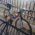
[Tags] Road bike


-
- LAPIERRE
- View other bikes
Kresnik
(
Male /
Japan )
0
0

 c2
c2GPX export
Are you sure you want to export GPX data for this trip?
![]()
![]()