![]()
![]()
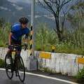
Morning Ride ![]()
2017/01/21 06:58 - 08:46 / Taiwan 陽明山
![]()
| Total distance: | 32.33 | km | Trip time: | 1:48'16 | Average speed: | 19 | km/h | |
|---|---|---|---|---|---|---|---|---|
| Ascending altitude: | 987 | m | Elapsed time: | 1:42'05 | Total calories: | 890 | kcal |
Morning Ride
- Taiwan・陽明山 2017/01/21 06:58 - 08:46
-
[Trip time] 1:48'16
[Total distance] 32.33km
[Average speed] 19km/h [Ascending altitude] 987m [Total calories] 890kcal
[Tags]
Takamitsu Yoshida
(
Male /
Japan )
0
0

 世明車行
世明車行


GPX export
Are you sure you want to export GPX data for this trip?
![]()
![]()