![]()
![]()
名栗有馬ダム走行記録 ![]()
2017/06/11 07:27 - 14:23 / Japan 名栗
![]()
| Total distance: | 55.25 | km | Trip time: | 6:56'02 | Average speed: | 10.3 | km/h | |
|---|---|---|---|---|---|---|---|---|
| Ascending altitude: | 1149 | m | Descending altitude: | 1053 | m | Total calories: | 571 | kcal |


名栗有馬ダム走行記録
- Japan・名栗 2017/06/11 07:27 - 14:23
-
[Trip time] 6:56'02
[Total distance] 55.25km
[Average speed] 10.3km/h [Ascending altitude] 1149m [Descending altitude] 1053m
[Total calories] 571kcal
[Tags]
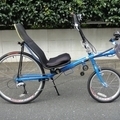
Greenspeed Anura デルタトライク 有馬渓谷観光釣り場


-
- Greenspeed Anura trike
Greenspeed Anura trike
View other bikes
轍。WADATI。Ruts ..... Lightning Phantom
(
Male /
Japan )
Lightning Phantom
0
0

 sngsym
GPX export
Are you sure you want to export GPX data for this trip?
![]()
![]()