![]()
![]()
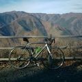
犬周回、しろくまパン ![]()
2017/06/17 10:08 - 15:14 / Japan 埼玉県ときがわ
![]()
| Total distance: | 71.39 | km | Trip time: | 5:06'14 | Average speed: | 23 | km/h | |
|---|---|---|---|---|---|---|---|---|
| Ascending altitude: | 623 | m | Elapsed time: | 3:01'18 | Total calories: | 1352 | kcal |
| Split time | 00:01’08 | |
|---|---|---|
| Lap time | 00:01’08 | |
| Trip lap distance | 10.11 | km |
| Average | Maximum | |||
|---|---|---|---|---|
| Lap speed | 10.3 | km/h | 25 | km/h |
| Lap heart rate | 138.5 | bpm | 163 | bpm |
| Lap cadence | 50.1 | rpm | 87.5 | rpm |
犬周回、しろくまパン
- Japan・埼玉県ときがわ 2017/06/17 10:08 - 15:14
-
[Trip time] 5:06'14
[Total distance] 71.39km
[Average speed] 23km/h [Ascending altitude] 623m [Total calories] 1352kcal
[Tags] Road bike


-
- Canondale SUPERSIXEVO
ロード最初の1台です。
View other bikes
Mitsuru
(
Male /
Japan )
初心者です。 よろしくお願いいたします。
0
0

 @たまりんど
GPX export
Are you sure you want to export GPX data for this trip?
![]()
![]()