![]()
![]()
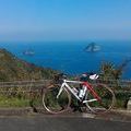
帰り道 ![]()
2017/08/14 11:20 - 11:57 / Not set
![]()
| Total distance: | 13.72 | km | Trip time: | 0:37'35 | Average speed: | 25.4 | km/h | |
|---|---|---|---|---|---|---|---|---|
| Ascending altitude: | 259 | m | Elapsed time: | 0:32'53 | Total calories: | 270 | kcal |
帰り道
- Not set・ 2017/08/14 11:20 - 11:57
-
[Trip time] 0:37'35
[Total distance] 13.72km
[Average speed] 25.4km/h [Ascending altitude] 259m [Total calories] 270kcal
[Tags]


-
- ANCHOR RA6
ANCHOR RA6 105、ULTEGRA、DURA-ACE、の混載コンポにカンパニョーロZONDAを履いてます。 DIY派
View other bikes
あさひる
(
Male /
Japan )
主に休日に彷徨いています。 夏から峠の楽しさを知り、機材とアクセサリが急増しました。
0
0

 tomato_no_papa
GPX export
Are you sure you want to export GPX data for this trip?
![]()
![]()