![]()
![]()
聖蹟桜ヶ丘 いろは坂 ![]()
2019/03/31 23:49 - 2019/04/01 00:39 / Japan 東京都
![]()
| Total distance: | 14.83 | km | Trip time: | 0:50'02 | Average speed: | 20.7 | km/h | |
|---|---|---|---|---|---|---|---|---|
| Ascending altitude: | 216 | m | Elapsed time: | 0:43'19 | Total calories: | 404 | kcal |
聖蹟桜ヶ丘 いろは坂
- Japan・東京都 2019/03/31 23:49 - 2019/04/01 00:39
-
[Trip time] 0:50'02
[Total distance] 14.83km
[Average speed] 20.7km/h [Ascending altitude] 216m [Total calories] 404kcal
[Tags] Road bike, Sunny, Night


-
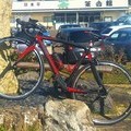
- Eddy Merckx EMX-5
Frame:EMX-5 Component:ULTEGRA R8000 Wheel:Campagnolo Zonda 2018年11月23日~
View other bikes
Kenjo1209
(
Male /
Japan )
EMX-5で走った分だけ記録します。 貧脚でヒルクライムが特に遅いです。 静岡か東京をゆるゆる走っています。 Twitter:@1284U
0
0

 暴走 老人
暴走 老人
GPX export
Are you sure you want to export GPX data for this trip?
![]()
![]()