![]()
![]()
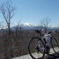
大福山~鹿野山 ![]()
2014/08/24 11:24 - 20:21 / Japan 千葉県
![]()
| Total distance: | 151.67 | km | Trip time: | 8:57'25 | Average speed: | 23.3 | km/h | |
|---|---|---|---|---|---|---|---|---|
| Ascending altitude: | 2194 | m | Elapsed time: | 6:17'30 | Total calories: | 625 | kcal |
| Split time | 00:01’08 | |
|---|---|---|
| Lap time | 00:01’08 | |
| Trip lap distance | 10.11 | km |
| Average | Maximum | |||
|---|---|---|---|---|
| Lap speed | 10.3 | km/h | 25 | km/h |
| Lap heart rate | 138.5 | bpm | 163 | bpm |
| Lap cadence | 50.1 | rpm | 87.5 | rpm |
大福山~鹿野山
- Japan・千葉県 2014/08/24 11:24 - 20:21
-
[Trip time] 8:57'25
[Total distance] 151.67km
[Average speed] 23.3km/h [Ascending altitude] 2194m [Total calories] 625kcal
[Tags] Road bike
こう
(
Male /
Japan )
こんにちは
0
0

 koji sato
GPX export
Are you sure you want to export GPX data for this trip?
![]()
![]()