![]()
![]()
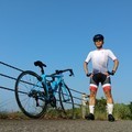
高屋神社ライド ![]()
2023/10/30 07:26 - 14:08 / Japan 観音寺市
![]()
| Total distance: | 111.12 | km | Trip time: | 6:41'39 | Average speed: | 22.7 | km/h | |
|---|---|---|---|---|---|---|---|---|
| Elapsed time: | 4:51'36 | Total calories: | 0 | kcal |
高屋神社ライド
- Japan・観音寺市 2023/10/30 07:26 - 14:08
-
[Trip time] 6:41'39
[Total distance] 111.12km
[Average speed] 22.7km/h [Total calories] 0kcal
[Tags] Road bike


-
- TREK1.5
高松周辺を主にTREKのエントリーモデル1.5で走ってます。 ロードバイクに乗り始め約1年、5000km程度を超え特に不満があるわけではないのですが、某社の試乗会でフルカーボンのバイクに乗ると次のバイクへの欲が高まってきました。 欲しい時が買い時!っかな。
View other bikes
tacobose
(
Male /
Japan )
ロード:Emonda SL6 & TREK1.5 & ALTERNA FLAT乗りです。 エントリーモデルを乗り継ぎ、ミドルクラスのEmonda SL6に乗り換えました。
0
0

 杏武
杏武GPX export
Are you sure you want to export GPX data for this trip?
![]()
![]()