![]()
![]()
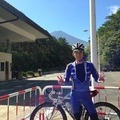
熊トレ45回目+東栄町 ![]()
2013/08/04 05:34 - 10:48 / Japan 浜松
![]()
| Total distance: | 121.38 | km | Trip time: | 5:14'07 | Average speed: | 28.5 | km/h | |
|---|---|---|---|---|---|---|---|---|
| Ascending altitude: | 1823 | m | Elapsed time: | 4:22'33 | Total calories: | 1603 | kcal |
| Split time | 00:01’08 | |
|---|---|---|
| Lap time | 00:01’08 | |
| Trip lap distance | 10.11 | km |
| Average | Maximum | |||
|---|---|---|---|---|
| Lap speed | 10.3 | km/h | 25 | km/h |
| Lap heart rate | 138.5 | bpm | 163 | bpm |
| Lap cadence | 50.1 | rpm | 87.5 | rpm |
熊トレ45回目+東栄町
- Japan・浜松 2013/08/04 05:34 - 10:48
-
[Trip time] 5:14'07
[Total distance] 121.38km
[Average speed] 28.5km/h [Ascending altitude] 1823m [Total calories] 1603kcal
[Tags] Road bike


-
- Look595
- View other bikes
yuzy1966
(
Male /
Japan )
0
0

 nop
nopGPX export
Are you sure you want to export GPX data for this trip?
![]()
![]()