![]()
![]()
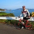
チャリ日誌35 ![]()
2014/12/27 08:19 - 13:08 / Japan 金岡~新岡山港~郡
![]()
| Total distance: | 66.98 | km | Trip time: | 4:48'29 | Average speed: | 20.3 | km/h | |
|---|---|---|---|---|---|---|---|---|
| Ascending altitude: | 1068 | m | Elapsed time: | 3:08'21 | Total calories: | 1336 | kcal |
| Split time | 00:01’08 | |
|---|---|---|
| Lap time | 00:01’08 | |
| Trip lap distance | 10.11 | km |
| Average | Maximum | |||
|---|---|---|---|---|
| Lap speed | 10.3 | km/h | 25 | km/h |
| Lap heart rate | 138.5 | bpm | 163 | bpm |
| Lap cadence | 50.1 | rpm | 87.5 | rpm |
チャリ日誌35
- Japan・金岡~新岡山港~郡 2014/12/27 08:19 - 13:08
-
[Trip time] 4:48'29
[Total distance] 66.98km
[Average speed] 20.3km/h [Ascending altitude] 1068m [Total calories] 1336kcal
[Tags]
貝殻山~金甲山で撃沈。児島半島を走った。


-
- TREK Madone2.1 red
- View other bikes
yamachan
(
Male /
Japan )
チャリを始めて、1年半。気分転換に乗る程度ですが、この先はイベントとかに出場してみたいです。
0
0

 カバヤ
カバヤGPX export
Are you sure you want to export GPX data for this trip?
![]()
![]()