![]()
![]()
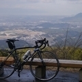
伊賀ツーリングルート開拓 ![]()
2015/06/24 08:02 - 12:44 / Japan 滋賀県+三重県
![]()
| Total distance: | 105.67 | km | Trip time: | 4:41'38 | Average speed: | 27.6 | km/h | |
|---|---|---|---|---|---|---|---|---|
| Ascending altitude: | 1871 | m | Elapsed time: | 3:43'32 | Total calories: | 1729 | kcal |
| Split time | 00:01’08 | |
|---|---|---|
| Lap time | 00:01’08 | |
| Trip lap distance | 10.11 | km |
| Average | Maximum | |||
|---|---|---|---|---|
| Lap speed | 10.3 | km/h | 25 | km/h |
| Lap heart rate | 138.5 | bpm | 163 | bpm |
| Lap cadence | 50.1 | rpm | 87.5 | rpm |
伊賀ツーリングルート開拓
- Japan・滋賀県+三重県 2015/06/24 08:02 - 12:44
-
[Trip time] 4:41'38
[Total distance] 105.67km
[Average speed] 27.6km/h [Ascending altitude] 1871m [Total calories] 1729kcal
[Tags] Road bike
伊賀へのツーリングで山道を含めるとどれくらい時間が掛かるのか?
そこから立ち寄れるスポットに目星が付けてみようと試走。
と同時に今回は比較的緩い登りの続くルートなので、長い距離のヒルクライムトレーニングの続きを。
結果、休憩が少な過ぎて、後半の御斉峠で撃沈寸前。


-
- ブリヂストン・レイダックRDR
ブリヂストン・アンカーの前身、レイダックのオールクロモリモデルRDR。
View other bikes
ドギー
(
Male /
Japan )
2014年秋からロードバイクに取り組み始めて、色んな事にチャレンジしたいです。 現在使用しているロードバイクはオーパスのアレグロ(カーボンフレーム)とブリヂストンのRADAC(クロモリフレーム)。
0
0

 こじまや
こじまや
GPX export
Are you sure you want to export GPX data for this trip?
![]()
![]()