![]()
![]()
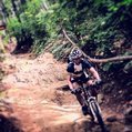
우면산-남태령다운-선바위다운-빵꾸 ![]()
2015/07/10 12:50 - 15:48 / Korea 잠실
![]()
| Total distance: | 27.62 | km | Trip time: | 2:57'23 | Average speed: | 13.7 | km/h | |
|---|---|---|---|---|---|---|---|---|
| Ascending altitude: | 440 | m | Elapsed time: | 1:41'30 | Total calories: | 335 | kcal |
| Split time | 00:01’08 | |
|---|---|---|
| Lap time | 00:01’08 | |
| Trip lap distance | 10.11 | km |
| Average | Maximum | |||
|---|---|---|---|---|
| Lap speed | 10.3 | km/h | 25 | km/h |
| Lap heart rate | 138.5 | bpm | 163 | bpm |
| Lap cadence | 50.1 | rpm | 87.5 | rpm |
우면산-남태령다운-선바위다운-빵꾸
- Korea・잠실 2015/07/10 12:50 - 15:48
-
[Trip time] 2:57'23
[Total distance] 27.62km
[Average speed] 13.7km/h [Ascending altitude] 440m [Total calories] 335kcal
[Tags]
0
0

 NOBU
NOBU
GPX export
Are you sure you want to export GPX data for this trip?
![]()
![]()