![]()
![]()
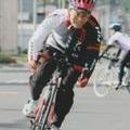
GPSカメラ大空の散歩 ![]()
2013/07/07 10:58 - 11:19 / Japan 北海道 当麻
![]()
| Total distance: | 6.53 | km | Trip time: | 0:20'54 | Average speed: | 25.8 | km/h | |
|---|---|---|---|---|---|---|---|---|
| Ascending altitude: | 292 | m | Descending altitude: | 297 | m | Total calories: | 974 | kcal |


GPSカメラ大空の散歩
- Japan・北海道 当麻 2013/07/07 10:58 - 11:19
-
[Trip time] 0:20'54
[Total distance] 6.53km
[Average speed] 25.8km/h [Ascending altitude] 292m [Descending altitude] 297m
[Total calories] 974kcal
[Tags] Other avtivity, Plain, Summer
GPSカメラこんな使い方もできますね


-
- ANCHOR RFX8 Eq 2011
初のカーボンバイク、ペダルビンディングにTRY。 ホイールをDuraAce C24にレベルアップし、より快適に成りました。
View other bikes
keian_ja8dni
(
Male /
Japan )
定年退職後の第二の人生として、自転車遊びに目覚めました。 貧脚ですが丘登りが楽しいです。挫折の連続ですが、TRY・TRYで前を向いて日々走っています。 blog も少しづつ更新しています。良かったら覗いてみてください。 http://ja8dni.cocolog-nifty.com/blog/
0
0

 クサムス
クサムス

GPX export
Are you sure you want to export GPX data for this trip?
![]()
![]()