![]()
![]()
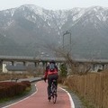
三国林道から高山ダム ![]()
2015/10/12 09:00 - 17:27 / Japan 和束
![]()
| Total distance: | 108.77 | km | Trip time: | 8:27'10 | Average speed: | 15.3 | km/h | |
|---|---|---|---|---|---|---|---|---|
| Ascending altitude: | 2179 | m | Elapsed time: | 6:46'54 | Total calories: | 663 | kcal |
| Split time | 00:01’08 | |
|---|---|---|
| Lap time | 00:01’08 | |
| Trip lap distance | 10.11 | km |
| Average | Maximum | |||
|---|---|---|---|---|
| Lap speed | 10.3 | km/h | 25 | km/h |
| Lap heart rate | 138.5 | bpm | 163 | bpm |
| Lap cadence | 50.1 | rpm | 87.5 | rpm |
三国林道から高山ダム
- Japan・和束 2015/10/12 09:00 - 17:27
-
[Trip time] 8:27'10
[Total distance] 108.77km
[Average speed] 15.3km/h [Ascending altitude] 2179m [Total calories] 663kcal
[Tags]
kabo
(
Male /
Japan )
0
0

 なっくん
なっくんGPX export
Are you sure you want to export GPX data for this trip?
![]()
![]()