![]()
![]()
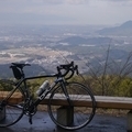
雨上がりの三国越林道へ ![]()
2016/01/30 13:00 - 16:59 / Japan 滋賀県+京都府
![]()
| Total distance: | 98.22 | km | Trip time: | 3:59'01 | Average speed: | 26.9 | km/h | |
|---|---|---|---|---|---|---|---|---|
| Ascending altitude: | 1963 | m | Elapsed time: | 3:36'14 | Total calories: | 1608 | kcal |
| Split time | 00:01’08 | |
|---|---|---|
| Lap time | 00:01’08 | |
| Trip lap distance | 10.11 | km |
| Average | Maximum | |||
|---|---|---|---|---|
| Lap speed | 10.3 | km/h | 25 | km/h |
| Lap heart rate | 138.5 | bpm | 163 | bpm |
| Lap cadence | 50.1 | rpm | 87.5 | rpm |
雨上がりの三国越林道へ
- Japan・滋賀県+京都府 2016/01/30 13:00 - 16:59
-
[Trip time] 3:59'01
[Total distance] 98.22km
[Average speed] 26.9km/h [Ascending altitude] 1963m [Total calories] 1608kcal
[Tags] Road bike
心肺機能向上には心拍数を頻繁に上下させた方が効果があると聞いて、アップダウンの続くルートを考慮。
未明まで降り続いた雨の影響で、最適かなと思った所はパスして三国越林道へ。
宇治田原から信楽へと抜けるルートを選択したけれど、童仙房前後で脚が終了。
ランの影響が残っていたな…


-
- ブリヂストン・レイダックRDR
ブリヂストン・アンカーの前身、レイダックのオールクロモリモデルRDR。
View other bikes
ドギー
(
Male /
Japan )
2014年秋からロードバイクに取り組み始めて、色んな事にチャレンジしたいです。 現在使用しているロードバイクはオーパスのアレグロ(カーボンフレーム)とブリヂストンのRADAC(クロモリフレーム)。
0
0

 ドギー
ドギー
GPX export
Are you sure you want to export GPX data for this trip?
![]()
![]()