![]()
![]()
手賀沼CRから利根川を下る ![]()
2016/05/01 12:23 - 15:46 / Japan 手賀沼サイクリングロード、利根川サイクリングリード
![]()
| Total distance: | 62.48 | km | Trip time: | 3:22'13 | Average speed: | 26.5 | km/h | |
|---|---|---|---|---|---|---|---|---|
| Ascending altitude: | 315 | m | Elapsed time: | 2:45'47 | Total calories: | 1199 | kcal |
手賀沼CRから利根川を下る
- Japan・手賀沼サイクリングロード、利根川サイクリングリード 2016/05/01 12:23 - 15:46
-
[Trip time] 3:22'13
[Total distance] 62.48km
[Average speed] 26.5km/h [Ascending altitude] 315m [Total calories] 1199kcal
[Tags] Road bike, Training, Lake
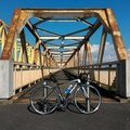
エモンダで初めて昼間走った。正直、あんまりデファイとの違いは感じない。舗装に小石が見えるような区間では若干振動がマイルドかな。プラシーボ効果のような気もする。ライディングポジションも少しハンドルが低くて時間が経ってからきついような気がする。しかし、この色はいい。カエル色。カワサキワークスのライムグリーン。


-
- TREK EMONDA SL5
鮮やかなライムグリーンに一目惚れ。でも高価。デファイだってあるし、必要ないじゃん。そう、その通り。でも購入(^^)。
View other bikes
okiba
(
Not set )
~2015年3月 神奈川県横浜市都筑区に居住・主に鶴見川CRを走行、2015年4月~2017年3月 千葉県我孫子市に居住・主に手賀沼CRと利根川CRを走行、2017年4月~ 新潟県新潟市中央区に居住中・主に国道402号を走行。
0
0

 kaiohmaru
GPX export
Are you sure you want to export GPX data for this trip?
![]()
![]()