![]()
![]()
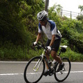
阿蘇ラピュタの道サイクング ![]()
2011/10/16 13:07 - 16:02 / Japan 阿蘇ラピュタの道
![]()
| Total distance: | 34.87 | km | Trip time: | 2:55'36 | Average speed: | 15 | km/h | |
|---|---|---|---|---|---|---|---|---|
| Ascending altitude: | 640 | m | Descending altitude: | 648 | m | Total calories: | 612 | kcal |


阿蘇ラピュタの道サイクング
- Japan・阿蘇ラピュタの道 2011/10/16 13:07 - 16:02
-
[Trip time] 2:55'36
[Total distance] 34.87km
[Average speed] 15km/h [Ascending altitude] 640m [Descending altitude] 648m
[Total calories] 612kcal
[Tags] Long touring, Road bike, Autumn
一度行ってみたかった、天空の道(ラピュタの道)サイクリングをしてきました。
天候に恵まれ、最高の絶景は疲れを吹き飛ばしてくれました。


-
- BOMA allumer
- View other bikes
たかちゃん
(
Male /
Japan )
自転車クラブばってん長崎の事務局長です。
0
6

 sugichan
GPX export
Are you sure you want to export GPX data for this trip?
![]()
![]()