![]()
![]()
我孫子→関宿城公園 ![]()
2015/11/29 09:56 - 11:46 / Japan 利根川サイクリングロード
![]()
| Total distance: | 36.29 | km | Trip time: | 1:49'50 | Average speed: | 26.6 | km/h | |
|---|---|---|---|---|---|---|---|---|
| Ascending altitude: | 236 | m | Elapsed time: | 1:22'36 | Total calories: | 690 | kcal |
我孫子→関宿城公園
- Japan・利根川サイクリングロード 2015/11/29 09:56 - 11:46
-
[Trip time] 1:49'50
[Total distance] 36.29km
[Average speed] 26.6km/h [Ascending altitude] 236m [Total calories] 690kcal
[Tags] Road bike, Training, Riverside
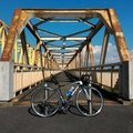
我孫子から利根川CRで関宿城公園までの往路。晴れてるけど時期も時期なので結構寒い。冬タイツ、冬ジャケ、冬アンダー、冬グローブ、耳カバーと完全装備。芽吹大橋で自転車無しの写真を撮った。
okiba
(
Not set )
~2015年3月 神奈川県横浜市都筑区に居住・主に鶴見川CRを走行、2015年4月~2017年3月 千葉県我孫子市に居住・主に手賀沼CRと利根川CRを走行、2017年4月~ 新潟県新潟市中央区に居住中・主に国道402号を走行。
0
0

 nobu
nobu
GPX export
Are you sure you want to export GPX data for this trip?
![]()
![]()